| |
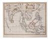
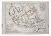
Charles Wilson (19th century), large folding chart of The Philippines, 78 x 65cm
£70 - 100
|
|
|
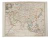
Herman Moll (d. 1732), large hand-coloured map - 'Asia' presentation to William, Lord Cowper, Lord High Chancellor of Great Britain', printed D. Midwinter, Thomas Bowles, Philip Overton, 1717, 58cm x 97cm
£300 - 500
|
|
| |
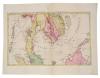
Gerhard Mercator (1512-1594), hand-coloured map - 'Asia', (1607), Latin text verso, 15cm x 19cm.
£60 - 100
|
|
| |
Gerhard Mercator (1512-1594), hand-coloured map 'Indiae Orientalis', (1607), Latin text verso, 15cm x 19cm.
£60 - 100
|
|
| |
Gerhard Mercator (1512-1594), hand-coloured map - 'Insulae Indiae Orientalis' (1607), Latin text verso, 15cm x 19cm.
£60 - 100
|
|
| |
Johannes Van Keulen (1654-1715), engraved map - Sumatra, Malacca, Sincapoera, Banda en Sunda (1753). Plate 50cm x 112cm.
£300 - 500
|
|
| |
Samuel Dunn (d 1794), hand-coloured map - 'Africa and its several regions', published Laurie & Whittle, 1794, 33cm x 46cm.
£80 - 120
|
|
| |
John Speed (1552-1629), hand-coloured map - 'Stafford Countie and Towne', sold by Thomas Bassett in Fleet Street and Ric. Chiswell in St. Paul's Churchyard, 39cm x 51cm, framed.
£50 - 100
|
|
| |
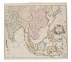
John Senex (d.1740), hand-coloured map - 'A New Map of Asia', 1721, 50cm x 59cm
£150 - 250
|
|
|
John Senex (d.1740), hand-coloured map - 'A New Map of Asia', 1721, 50cm x 59cm
£150 - 250
|
|
|
John Senex (d.1740), hand-coloured map - 'A New Map of India and China', 1721, 50cm x 59cm
£150 - 250
|
|
| |
John Senex (d.1740), hand-coloured map - 'A New Map of India and China', 1721, 50cm x 59cm.
£100 - 150
|
|
|
Joachim Ottens (17th/18th century), hand-coloured map - 'Le Royaume de Siam Avec Les Royaumes gui Luy sont tributaires', 1740, 36cm x 46cm.
£120 - 160
|
|
| |
John Senex (d.1740), hand-coloured map - 'A New Map of Asia', 1721, 50cm x 59cm
£70 - 100
|
|
|
John Speed (1552-1629), hand-coloured map - 'A new map of East India', 1676, English text verso, 39cm x 49cm.
£300 - 500
|
|
|
Jan Jansson (1596-1664), hand-coloured map - 'Insulae Javae....' 1657-1658, Latin text verso, 41cm x 53cm.
£200 - 300
|
|
| |
N Visscher - hand coloured map - 'Asiae Nova Delineatio', circa 1680, 43 x 54cm
£100 - 150
|
|
|
Herman Moll (d. 1732) hand coloured map - 'The Principle Islands of the East Indies', 18 x 26
£50 - 70
|
|
| |
Herman Moll (d. 1732) hand coloured map - 'The Philippine Islands and others of the East Indies', 18 x 26
£50 - 70
|
|
| |
Herman Moll (d. 1732) hand coloured map - 'The East Part of India', 26 x 16cm
£50 - 70
|
|
| |
Herman Moll (d. 1732) engraved map - 'A Map of the Streights of Malacca', 16 x 26cm, together with another. (2)
£60 - 100
|
|
| |
Jan Jansson (1596-1664), hand-coloured map - 'Insularum Moluccarum', 39cm x 50cm
£100 - 150
|
|
| |
Henry Abraham Chatelain (1684-1743), engraved map - 'Carte des Indies, de la Chine...' 1715, 51cm x 49cm
£60 - 100
|
|
|
Henry Abraham Chatelain (1684-1743), engraved map - 'La Royaume de Siam...', 38 x 44cm,
£60 - 100
|
|
|
Vicenzo Maria Coronelli (1650-1718), engraved map - 'Isole dell Indie divise in Filippine, Moluccae e Della Sonda', 1696, Latin text verso, 46cm x 61cm.
£120 - 160
|
|
| |
Thomas Conder (1775-1801), engraved map - 'East India Islands', 1778, 34cm x 39cm
£60 - 100
|
|
| |
Thomas Conder (1775-1801), hand coloured map - 'Asia', 1778, 34cm x 39cm
£70 - 100
|
|
| |
John Cary (c. 1754-1835), hand-coloured map - 'A New Map of Asia', 1806, 52 x 57cm
£100 - 150
|
|
| |
Emanuel Bowen (1720-1767), engraved map - 'A new & accurate map of Asia', 1747, 35cm x 43cm, together with another 'Map of the East Indies'. (2)
£100 - 150
|
|
|
Nicolas de Fer (1646-1720), hand-coloured map - 'Les Isles Philippines...', dated 1702, 22 x 34cm
£60 - 100
|
|
| |
Pierre van der Aa (1659-1733), engraved map - 'Les Indes Orientales', 29cm x 34cm, 1714, together with another 'Les Isles de Banda'. (2)
£100 - 150
|
|
| |
Guijelmus Blaeu (1571-1636) engraved map - 'India Orientalis et Insulae Adiecentes', 27 x 34cm
£70 - 100
|
|
| |
Cornelis de Bruyn engraved map - 'De Nette Koers Wysing van de Reys van Gamron na Batavia en Wederom van Batavaia na Gamron', 1714, 24 x 30cm
£50 - 70
|
|
| |
Nicolas Vischer (1618-1679), hand-coloured map - 'Indiae Orientalis', after Petrum Schenk, 1690, 47cm x 57cm together with seven 18th or early 19th century maps by Jeffries and others. (8)
£100 - 150
|
|
| |
Group of predominantly 19th century maps, charts and book plates
£50 - 100
|
|
| |
Zacharie Chatelain (d.1723) engraving - 'Vue & description de la ville de Siam, des pagodes, des Talapoins ou religieux de ce pais. . .' 39 x 49cm, together with another and group of 18th century engravings relating to the Far East. (Qty)
£100 - 150
|
|
| |
Large group of books relating to Cartography with specific reference to the Far East and Philippines, various facsimile maps and related materials
£100 - 200
|
|
| |
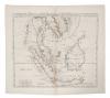
Alessandro Mallespina (18th / 19th century) engraved chart - 'Carta General del archipielago De Filipinas' 1808, two sheets, each 58 x 90cm,
£50 - 100
|
|
| |
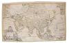
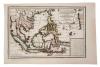
Father Vincenzo Maria Coronelli (1650-1718) hand coloured map - 'Asia' circa 1690, 59 x 87cm
£300 - 500
|
|
| |
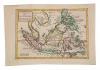
George Moritz Lowitz (1722-1774) hand coloured map 'Cart hydrographique & chorographique des Isles Philippines', circa 1750, 97 x 53cm
£400 - 600
|
|
| |
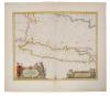
James Horsburgh (1762-1836) engraved chart - 'China Sea' (sheet II) dated 1823, 100 x 69cm
£200 - 300
Other Owners
|
|
|
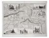
Thomas Sparrow, engraved map, 'Survey of the Ancient Town and Borough of Colchester in the County of Essex', printed and sold by W. Keymer, Colchester, 1767, 53 x 70cm
£150 - 200
|
|
| |
The Atlas To Guthrie's System of Geography, comprising frontispiece with index of maps and complete with 26 hand tinted maps, the first dated 1783, marbled card end boards, 39 x 26cm
£400 - 600
|
|
| |
Jan Jansson (1588-1664) hand coloured map - 'Alsatia Inferior' published Amsterdam, circa 1640, 36 x 43cm, glazed frame
£80 - 120
|
|
| |
John Speede and John Norden, hand coloured map of Essex, dated 1662, 42 x 52cm, glazed frame
£80 - 120
|
|
| |
Herman Moll two 18th century hand coloured maps - 'The South part of Africa and the Island of Madagascar'; 'Negroland and Guinea' each 21 x 29cm, ink glazed Hogarth frames. (2)
£100 - 150
|
|
| |
18th century hand-coloured engraving - The Bay & Harbour of Vigo, 38 x 48cm, together with two reprints of local 18th century engravings - Harwich, Prospect of Colchester, all in glazed frames. (3)
£70 - 100
| Works of Art
commencing at 12.00pm | |
|
| |
Qing style Chinese lacquer table screen, in relief with fantastical landscape scene, within relief carved wooden frame, 54cm wide
£200 - 300
|
|
| |
Antique Japanese scroll painting, depicting family of monkeys, script and seal marks, 108 x 55cm, with silk border
£200 - 300
|
|
| |
Japanese bronze vase, slender baluster form, moulded with heron, character mark to base, 49cm high
£100 - 150
| By Direction of a Gentleman | |
|