The Christopher Beresford-Jones Collection of Antique Maps and Charts (Part Two) |
|
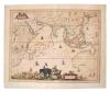
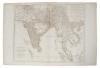
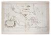
Carel Allard (1648-1709), hand-coloured map - 'Nova Tabula India Orientalis', 1697, 45cm x 56cm.
£150 - 200
|
|
| |
George Anson (1697-1762), engraved chart - 'A Chart of The Channel in the Philippine Islands through which passes the Manilla Galleon....' R.W Seale Sculpt. Taken from 'A voyage around the World in the years 1740-1744', compiled by Benjamin Robins, 1749, 70cm x 54cm (patch repairs), together with 'A plan of the Harbour of Acapulco / A plan of the Bay of Manila', by the same hand (2).
£40 - 60
|
|
|
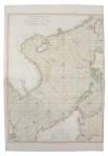
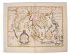
Jean Baptiste Bourguignon d' Anville (1697-1782), hand-coloured map - 'Seconde Partie de la Carte d' Asie continent La Chine, et partie de la Tartarie. L'Inde....', dated 1752, 50cm x 70cm.
£70 - 100
|
|
| |
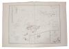
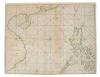
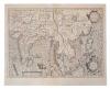
Jean Baptiste Nicolas Denis Apres de Mannevillette (1707-1780), engraved chart - 'Carte Plate du Golfe de Siam'; 50 x 35cm
£60 - 100
|
|
| |
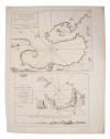
Jean Baptiste Nicolas Denis Apres de Mannevillette (1707-1780), engraved chart - 'A plan of the Isles of Mercury / Plan of Junkeylon Island' dated 1778, 34 x 48cm,
£60 - 100
|
|
| |
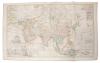
Group of 19th century maps of the Far East - to include Admirality Chart - Ports in the Philippines, 1903; Aaron Arrowsmith - Chart of Philippines, Chart of the East India Islands; Eugene Andiveau Goujon - Carte Generale des Indies Orientales Indiquant Les possessions Anglaises'; John Arrowsmith - five hand-coloured charts - Asia, Asiatic Archiplelago, etc. (9).
£100 - 150
|
|
|
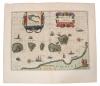
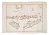
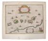
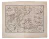
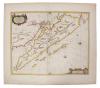
Guijelmus Blaeu (1571-1638), hand-coloured map - 'Moluccae Insulae Celeberrimae', 1630, German text verso, 38cm x 48cm.
£250 - 300
|
|
|
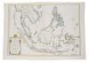
Guiljelmus Blaeu (1571-1638), hand-coloured map - 'India que Orientalis dicitur et Insulae Adiacentes', 1635, Dutch text verso, 45cm x 51cm
£400 - 600
|
|
|
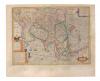
Jan Van Braam (18th century), engraved map - 'Kaart der Zuyd-Wester Eylanden van Banda', 1724, 34cm x 47cm.
£40 - 60
|
|
| |
Group of 19th century engraved maps - to include John Bartholomew 'Malay or Indian Archipelago'; 'Indian Archipelago'; Blackie & Son - three mid-19th century Far Eastern maps; Adrien Hubert Brue (1786-1832), two large maps - 'Achipel. D' Asie'; 'Des Indies'; four by Adam Black (1784-1874) (11).
£60 - 100
|
|
| |
Rigobert Bonne (1727-1795), hand-coloured chart - 'Carte Des Hydro-Geographique Des Indes Orientales', dated 1771, in four parts, each plate 30cm x 40cm.
£150 - 200
|
|
| |
Rigobert Bonne (1727-1795), group or engraved maps of Far Eastern subjects - some hand-coloured, various sizes (7).
£200 - 300
|
|
| |
Rigobert Bonne (1727-1795), hand coloured map - 'Les Isles Philippine', 23 x 33cm, together with another of the same subject. (2)
£40 - 60
|
|
| |
Henry Abraham Chatelain (1684-1743), engraved map - 'Carte des Indies, de la Chine....', 1715, 51cm x 49cm, together with another - 'La Royaume de Siam....' (2).
£80 - 120
|
|
| |
Philippe Cluver (1580-1622), hand-coloured map - 'Indiae Orientalis', 22cm x 26cm, 1697, together with another - 'Isles de L'Indie Orientale' (2).
£80 - 120
|
|
| |
Thomas Conder (1775-1801), two hand-coloured maps - 'East India Islands'; 'Asia', 1778, 34cm x 39cm.
£80 - 120
|
|
| |
Three 19th century coloured maps of the Far East - Thomas Clerk; Cooper; George Colton.
£20 - 30
|
|
|
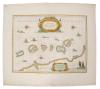
Alexander Dalrymple (1737-1808), engraved chart - 'Sooloo Archipelago', 1771, 50cm x 64cm.
£30 - 50
|
|
|
Hendrik Doncker (1626-1699), hand-coloured map - 'Oost Indien', 1670, 43cm x 53cm.
£100 - 150
|
|
| |
Samuel Dunn (d. 1794), group of four hand-coloured maps of the Far East, 1786/1789, each approximately 32cm x 45cm.
£100 - 150
|
|
|
Nicolas de Fer (1646-1720), hand-coloured map - 'L' Asie', dated 1722, 47cm x 60cm
£100 - 150
|
|
| |
Nicolas de Fer (1646-1720), hand-coloured map - 'Isles Philippines et la Sonde' 23 x 35cm, together with descriptive text leaf (2).
£60 - 100
|
|
| |
Group of 19th century maps of Far East - including five by Archibald Fullarton & Co., large hand-coloured map of Asia, by William Faden, small map by Findlay and two charts by Depot de Cartes et Plans de la Marine, Paris (9).
£100 - 150
|
|
|
Capt. George Hayter (18th century), hand-coloured map - 'A General Chart of the China Sea', dated 1778, 84cm x 62cm.
£80 - 120
|
|
| |
Homan Heirs (1730-1813), hand-coloured map - 'Indes Orientalis', dated 1748, 50cm x 89cm.
£100 - 150
|
|
| |
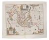
Henricus Hondius (1597-1651), hand-coloured map - 'India Orientalis ..Insulae Adiacentes', 1638, French text verso, 39cm x 49cm.
£250 - 300
|
|
| |
Henry Gregory (18th century), engraved chart - 'Gulph of Siam', 1787, 53cm x 66cm, together with small hand-coloured map of Asia by John Gibson and 19th century chart - 'Birmah, Anam & Siam, 1829 (3).
£30 - 50
|
|
|
William Herbert (1718-1795), hand-coloured map - 'A correct Chart of The China Seas...', 1758, 59cm x 77cm
£200 - 300
|
|
| |
William Herbert (1718-1795), engraved chart, 'Junk-Seilon' 76 x 57cm, together with three others by the same hand. (4)
£100 - 150
|
|
|
William Herbert (1718-1795), engraved chart - 'A plan of the Bay of Manilla'; 'A plan of Pulo Condore' two on one sheet, the first 30 x 39cm
£50 - 70
|
|
|
Jan Jansson (1596-1664), hand-coloured map - 'Insularum Moluccarum', 1656-1661, English text verso, 39cm x 50cm.
£80 - 120
|
|
| |
Jan Jansson (1596-1664), engraved miniature map - 'Die Indianische Insulen' (Mercator), German text verso, 1651, together with another from the same series, both 14cm x 19cm.
£30 - 50
|
|
|
Thomas Jeffreys (c. 1710-1771), engraved chart - 'A general map of the East Indies', 1781, 57cm x 71cm,
£80 - 120
|
|
|
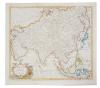
Jodocus Hondius (1563-1612), hand-coloured map - 'Asiae Nova Decsriptio Auctore', 1606, 37cm x 50cm.
£50 - 70
|
|
| |
Henricus Hondius (1597-1651), hand-coloured map - 'India Orientalis ..Insulae Adiacentes', 1638, Latin text verso, 39cm x 49cm.
£50 - 70
|
|
|
Jan Jansson (1596-1664), hand-coloured map - 'Insularum Moluccarum', 39cm x 50cm
£100 - 150
|
|
|
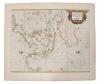
Gerhard Mercator (1512-1594), engraved map - 'India Orientalis' (J.Hondius 1609), Latin text verso, 36cm x 48cm.
£200 - 300
|
|
|
Jacques Nicolas Bellin (1703-1772), engraved chart - 'Carte Reduite Des Detroits de Malaca, Sincapoera et du Gouverneur', dated 1755, 58cm x 90cm
£100 - 150
|
|
|
Edward Wells (1667-1727), hand-coloured map - 'A New Map of the East Indies', 1700, 36cm x 50cm.
£80 - 120
|
|
| |
Edward Wells (1667-1727), hand-coloured map - 'A New Map of the East Indies', 1700, 36cm x 50cm
£50 - 70
|
|
|
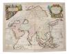
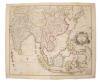
Herman Moll (d. 1732), large hand-coloured map - 'Asia', presentation to William, Lord Cowper, Lord High Chancellor of Great Britain', printed - D. Midwinter, Thomas Bowles, Philip Overton, 1717, 58cm x 97cm.
£150 - 200
|
|
|
Abraham Ortelius (1527-1598), engraved map - 'Indiae Orientalis Insuralarumque Adiacientium Typus', 1587, Spanish text verso, 35cm x 49cm.
£250 - 300
|
|
|
Jan Jansson (1596-1664), hand-coloured map - 'Sumatrae' 1657-1658, 42cm x 52cm
£100 - 150
|
|
| |
Jan Jansson (1596-1664), hand-coloured map - 'Sumatrae' 1657-1658, 42cm x 52cm
£50 - 70
|
|
|
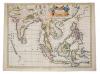
John Senex (d.1740), hand-coloured map - 'A New Map of India and China', 1721, 50cm x 59cm.
£70 - 100
|
|
|
John Speed (1552-1629), hand-coloured map - 'A new map of East India', 1676, English text verso, 39cm x 49cm.
£200 - 300
|
|
| |
Johannes Van Keulen (1654-1715), hand-coloured map - 'Pas Kaart van de Vaar weg van Straat Blanca af totaan palo Temaon inhoutende de Straaten Drioens, Sabon, Brouwer en Sincapoera', 1753, 57cm x 47cm
£200 - 300
|
|
| |
Thomas Kitchin (1718-1784), hand-coloured map - 'Asia / From the best authorities', 18cm x 23cm.
£30 - 40
|
|
|
Thomas Kitchin (1718-1784), hand-coloured map - 'Asia, agreeable to the most approved maps and charts', engraved for Millar's Complete and Universal System of Geography, 1783, 34cm x 39cm.
£60 - 100
|
|
| |
Thomas Kitchin (1718-1784), engraved map - 'A general map of the East Indies and that part of China where the Europeans have any settlements or commonly any trade', engraved for the London Magazine, 1747-1760, trimmed to beyond plate edge on left side, 31cm x 41cm.
£50 - 70
|
|