| |
Vanderbilt, William K. To Galapagos on the Ara 1926, number 730 of 399 copies in buckram from an edition of 900, 30 coloured plates, tissue guards, some spotting, original buckram, watermarked, 4to, Privately Printed, [1927] £100-150
|
|
|
Wafer, Lionel. A New Voyage and Description of the Isthmus of America, giving an account of the author's abode there..., first edition, folding engraved map, 3 folding engraved plates, 2pp. of publisher's advertisements at end, waterstained throughout, P repaired with very slight loss, occasional rust-marks and mould-marks, modern rexine, bookplate of Bath Municipal Library, 8vo, London: James Knapton, 1699 £300-500
|
|
| |
Weber, Christian Friedrich. The Present State of Russia, 2 volumes, first English edition, large folding engraved map, torn, large folding plan of St. Petersburg, torn and repaired, some spotting and soiling, contemporary panelled calf, joints slightly cracked, rubbed, bookplate of Bath Public Reference Library, occasional blindstamps throughout, 8vo, London: W. Taylor, 1722-23 £200-300
|
|
|
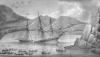
Weddell, James. A Voyage to the South Polar Sea, performed in the Years 1822-24, first edition, hand-coloured aquatint frontispiece, 6 aquatint plates, including 2 folding of coastal views, 8 engraved maps and charts, 6 folding and 2 single-page, one torn, errata slip, without advertisements, some occasional spotting and browning, contemporary diced calf, upper board detached, head of spine chipped, bookplate of G. H. Walker Heneage, 8vo, London: Longman, Hurst, Rees, Orme, Brown and Green, 1825 [Rosove 345] £700-900 See illustration
|
|
| |
Wells, James W. Exploring and Travelling Three Thousand Miles through Brazil, 2 volumes, first edition, 2 folding maps, creased, 32 page publisher's catalogue, original cloth, soiled and shaken, bookplate of Bath Public Reference Library, blindstamps, 8vo, London: Sampson, Low, Marston, Searle and Rivington, 1886 £50-80
|
|
|
|
| |
Bartholomew, John. The Imperial Map of England and Wales, 17 double-page maps, index, some spotting, contemporary half morocco, bookplate of Bath Public Reference Library, folio, London: A. Fullarton, [c.1866] £70-90
|
|
| |
Blaeu, Willem. Nottinghamiensis, Nottingham Shire, engraved map, hand-coloured in outline, Latin text verso, 500mm x 385mm, [Amsterdam, c.1646], framed and double-glazed £100-150
|
|
| |
Blaeu, Willem and Jan. Territorium Norimbergense, hand-coloured engraved map, stained in lower margin, 435mm x 540mm, Amsterdam, [n.d.] £50-80
|
|
| |
Blaeu, William. Zeelandia Comitatus, engraved map, hand-coloured in outline, 500mm x 382mm, [?Amsterdam, c.1670] £50-70
|
|
| |
Bowen, Emanuel. An Accurate Map of the County of Derby, Divided into Its Hundreds, engraved map, hand-coloured in outline, slightly torn along fold, 535mm x 695mm, Carrington Bowles, [c.1760], framed and glazed £60-80
|
|
| |
Bowen, Emanuel. An Accurate Map of Somersetshire, hand-coloured engraved map, 497mm x 405mm, Robert Sayer, 1777; A New and Accurate Chart of the World, hand-coloured engraved map, 442mm x 360mm, [c.1747], both framed and glazed (2) £100-150
|
|
|
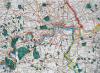
Cary, John. Cary's Improved Map of England and Wales, with a considerable portion of Scotland, engraved title, creased and soiled, index map and 65 engraved sheet maps, hand-coloured in outline, contemporary half morocco, rubbed, large oblong folio, London: G. and J. Cary, 1832 £1000-1500 See illustration
|
|
| |
Collins, Captain Grenville. Part of Devonshire [Dartmouth and Topsham], hand-coloured engraved chart, 566mm x 448mm, [c.1693], framed and glazed This chart has been extracted from Great Britain's Coasting Pilot, 1693. £100-150
|
|
| |
D'Anville, Jean Baptiste. An Atlas of Ancient Geography, 12 hand-coloured engraved maps, 11 double-page, some spotting, contemporary half calf, worn, bookplate of Bath Public Reference Library, blindstamps throughout, folio, London: R.H. Laurie, [c.1821] £80-120
|
|
|
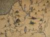
Drayton, Michael. Somersetshere, Wiltshere, hand-coloured engraved map, browned, cropped, 332mm x 248mm, [c.1622] £150-200 See illustration
|
|
| |
Gail, J.B. Atlas pour servir a l'etude de l'Histoire Ancienne, 55 engraved plates and plans, mostly folding, some spotting, original boards, worn, 4to, Paris: Auguste Delalain, 1815; [Anon] Geographia Antiqua, 32 engraved plates, mostly double-page, rather spotted, modern half calf, 4to, London: C and J. Rivington, 1821, both with bookplate of Bath Public Reference Library, blindstamps (2) £60-80
|
|
| |
Greenwood, Charles and James. Map of the County of Southampton, from an Actual Survey, hand-coloured folding engraved map on 60 sections, backed on linen, in contemporary morocco case, worn, 1500mm x 1560mm, London: Greenwood, Pringle & Co., 1826 £200-300
|
|
| |
Heirs, Hermann. Regnorum Magnae Britanniae et Hiberniae Mappa Geographica, hand-coloured engraved map, faded, 562mm x 520mm, Nuremberg, 1749, framed and glazed £60-80
|
|
| |
Keere, Peter van den. Dorcetshire, hand-coloured engraved map, 122mm x 84mm, [c.1665], framed and glazed; Mercator, G. Northumbr. Cumberladia Dunelm. Episcop, hand-coloured engraved map, 185mm x 135mm, [Amsterdam, c.1608]; and 4 others, county maps and city plans (6) £150-250
|
|
| |
Kip, William. Dorcestriae Comitatis, vulgo Dorsett, hand-coloured engraved map, 386mm x 275mm, [c.1637], framed and glazed £80-120
|
|
| |
Lewis, Samuel. Atlas to the Topographical Dictionary of Ireland, large folding engraved map and 32 single-page engraved maps, all hand-coloured in outline, some spotting, publisher's original cloth, spine chipped with loss, upper cover detached, 4to, London: S. Lewis & Co., 1849 £200-250
|
|
| |
Miscellaneous Maps. A collection of approx. 60 engraved and lithographed maps, including Kitchen's map of South America and numerous road strip maps from Carrington Bowles' atlas, loose, v.s. (a quantity) £100-200
|
|
| |
Morden, Robert. The Smaller Islands of the British Ocean, hand-coloured engraved map, 422mm x 355mm, Abel Swale, [c.1695]; Janssonius, Johannes. Hantoniae comitatus cum bercheria, hand-coloured engraved map, torn along fold, browned, 545mm x 438mm, [c.1700], both framed and glazed (2) £60-90
|
|
| |
Nordenskiold, A.E. Facsimile-Atlas, double-page maps, original half morocco, rubbed, folio, Stockholm, 1889; English County Maps in the Collection of the Royal Geographical Society, 2 parts, plates, loose, contemporary cloth folders, v.s., London: Royal Geographical Society, 1932; and one other, similar (4) £50-100
|
|
| |
Ogilby, John. The Roads from Exeter com. Devon to Dorchester and from Plimouth to Dartmouth, engraved strip map, hand-coloured in outline, 455mm x 320mm, [c.1676]; The Road from Oxford to Chicester, engraved strip map, hand-coloured in outline, 427mm x 350mm, [c.1676], both framed and glazed (2) £200-250
|
|
| |
Oretelius, Abraham. Septentrionalium regionum descrip., hand-coloured engraved map, 488mm x 360mm, Antwerp, [c.1580], framed and glazed £300-500
|
|
| |
Reynolds, James. The Oarsman's and Angler's Map of the River Thames from its Source to London Bridge, folding hand-coloured lithographed map, 162mm x 2068mm, James Reynolds and Sons, 1891 £40-60
|
|
| |
Saunders, Trelawney. An Atlas of Twelve Maps of India, 12 double-page maps, one backed on linen, most split along fold, original cloth, chipped, bookplate of Bath Public Reference Library, folio, London: Edward Stanford, 1889 £40-60
|
|
| |
Saxton, Christopher. Glocestriae sive Claudiocestriae comitat, hand-coloured engraved map, some browning, discoloured, 493mm x 380mm, 1577 [1579], framed and glazed £1200-1800
|
|
| |
Saxton, Christopher. Comitatus bercheriae vulgo barkshyre, hand-coloured engraved map, 322mm x 228mm, William Hole, [c.1610], framed and glazed £80-120
|
|
| |
Saxton, Christopher and William Hole. Monumethensis comitatus, hand-coloured engraved map, rather spotted, 350mm x 280mm, [c.1637]; Morden, Robert. Somersetshire, hand-coloured engraved map, 420mm x 360mm, [c.1753] and 4 others, v.s., all framed and glazed (6) £100-150
|
|
| |
Schenk, P. and G. Valk. Somersetensis comitatus: Somersetshire, hand-coloured engraved map, 491mm x 360mm, [c.1695] £200-300
|
|
|
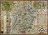
Speed, John. Wilshire, hand-coloured engraved map, vignette of Stonehenge and inset plan of Salisbury, neat repair to lower edge, 511mm x 382mm, G. Humble, [c.1614], framed and glazed £250-300 See illustration
|
|
| |
Speed, John. Oxfordshire described, engraved map, lower edges damaged by silverfish with some loss, stained along fold, English text on reverse, 530mm x 380mm, [c.1676], w.a.f., framed and double-glazed £100-200
|
|
| |
Speed, John. Glamorgan Shyre. With the sittuations of the cheife towne Cardyff and ancient Iandaffe described, hand-coloured engraved map, slightly faded, 508mm x 382mm, [c.1627] £120-180
|
|
| |
Speed, John. Somerset-Shire Described: and into Hundreds devided, with the plott of the famous and most wholsom waters and citie of the Bathe, hand-coloured engraved map, English text verso, 502mm x 372mm, [c.1627] £200-300
|
|
| |
Speed, John. Rutlandshire. With Oukham and Stanford her bordering neighbour, hand-coloured engraved map, some surface soiling, 510 x 384mm, c.1676, framed and glazed £50-80
|
|
| |
Speed, John. The Countie Westmorland and Kendale the Cheif Towne Described, hand-coloured engraved map, 500mm x 378mm, George Humble, [c.1611]; Morden, Robert. Westmorland, hand-coloured engraved map, 414mm x 358mm, Abel Swale, [c.1695], both framed and glazed (2) £80-120
|
|
| |
Thames Estuary. Engelandt, engraved map, hand-coloured in outline, inset vignette of the Thames, titled 'De Rivier van Londen', slightly soiled, some repair to margins, 445mm x 335mm, [?c.1640] £200-300 2098-2099. No Lots
| Photography | |
|
| |
Europe. Two late nineteenth century albums containing upwards of 150 mounted photographs, mostly of Scotland, Italy and Wales, many stock views, including examples by James Valentine, mostly 215mm x 160mm or less, but a few larger, contemporary half morocco, worn, folio, [c.1890] £100-150
|
|
| |
Frith, Francis. A group of 39 loose photographs, mostly of the Grindelwald region of Switzerland, mostly 257mm x 160mm or smaller, c.1890 £50-80
|
|
| |
Japan. An album of 50 mounted hand-tinted photographic views of Japan, mostly topographical or domestic scenes, tissue guards, each 250mm x 195mm, most captioned in the negative, in a lacquered album, distressed, oblong 4to, [c.1890] £200-300
|
|
| |
Kerim, A. Camera Studies in Iraq, 57 sepia photographs on 37 leaves, each captioned, some slight soiling, original boards, oblong 4to, Baghdad: A. Kerim, [c.1925] £150-250
|
|
| |
G. Sommer and Son. A series of 60 glass photographic slides of Italy, c.1910, each 82mm square, edged in black paper. £30-50
|
|
| |
Speed. A album of 38 mounted photographs of cars, speed boats and motorcycles, c.1930, including a series of 15 images by Beken & Son of the boat M.V. Voodoo, owned by Cyril Bone, most 280mm x 227mm or smaller, contemporary roan, rubbed, [c.1930] £200-250 2106-2109. No Lots
| Natural History, Science and Engineering | |
|
| |
[Anon] An Historical Narrative of the Great Plague at London, 1665: with An Abstract of the Most Common Opinions concerning the Causes, Symptoms, and Cure of that fatal Disorder, first edition, marginal notes cropped on Ff2-Ff3, modern cloth, bookplate of Bath Municipal Reference Library, blindstamps throughout, 8vo, London: W. Nicoll, 1769 £70-90
|
|
| |
Bacon, Francis. Sylva Sylvarum: or A naturall Historie, second edition, engraved portrait frontispiece, engraved additional title, some spotting, a few leaves marked, contemporary calf, worn, upper cover detached, folio, London: William Lee, 1628 £100-150
|
|
| |
Clifton, Francis. Hippocrates upon Air, Water, and Situation; upon Epidemical Diseases; and upon Prognosticks, in Acute Diseases especially, first edition, engraved portrait frontispiece, some light spotting, contemporary calf, rubbed, 8vo, London: J. Watts, 1734 £50-70
|
|
| |
Collins, Robert. A Short Sketch of the Life and Writings of the Late Joseph Clarke, Esq., M.D., first edition, inscribed 'With the Author's Complts to Dr. W. Fraser', some spotting, original cloth-backed boards, 8vo, London: Longmans, 1849; Adams, R. Abnormal Condition of the Ankle-Joint, inscribed 'For Francis White Esq., with Authrs regards', original cloth, 8vo, London: Marchant, 1835, bound with three similar works by the same author (2) £60-80
|
|