|
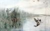
John George Sowerby (fl. 1876-1914) - Two limited edition prints - The shoot by a lake and by the sea, each 12.5ins x 20ins, No. 24, published by The Fine Art Society, London 1907, in painted oak frames and glazed £200-300
|
|
|
Deanne Coleborn (20th Century) - Six coloured etchings - "Circus", Nos 1 to 6, each 5ins x 5ins, each signed and titled in pencil, and all framed and glazed £200-300
|
|
|
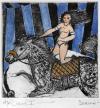
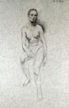
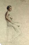
Kassandra Isaacson (20th / 21st Century) - Five works - Conte and charcoal - "Dancers", 27ins x 38.5ins; Pencil drawing - Nude study, 9.5ins x 7.75ins; three Giclee prints - "Aphrodite" 11.75ins x 8.25ins, "Narcissus and Echo" 11.5ins x 8ins, and "Angelica & Medaro" 8ins x 12ins (variously monogrammed and titled - mostly framed) £120-160
|
|
  |
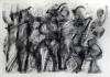
Hans Feibusch (1898-1998) - Folio of pencil drawings heightened with chalk - Mostly life studies, 20.5ins x 15.25ins (19) £300-400
|
|
|
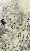
A collection of ephemera relating to the first Soho Fair, July 1955, organised by Monsieur Berlemont, proprietor of Maison Berlemont, 49 Dean Street, London, including - Joseph Lee (1901-1975) - Pen, ink and watercolour - Cartoon - "Alphonse got off his mark so smartly at yesterday's waiters....", 17.25ins x 10.5ins, signed "Lee", framed and glazed, together with a letter from Buckingham Palace congratulating M. Berlemont £150-200
Note: Drawing by Lee, Cartoon No. 6223, of July 11th 1955 from his series "London Laughs" featured in The Evening News
|
|
|
Wiktor Wilner (20th Century East German) - Folder of ten limited edition coloured lithographs - "Sankt Peters Burg" (No. 14 of 100), each approximately 19.25ins x 14.5ins, in card folder with printed title label to front, as well as a small quantity of other East German prints, various (all unframed and in folio) £80-120
|
|
|
|
|
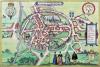
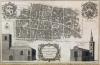
Georg Braun (1541-1622) and Frans Hogenberg (circa 1536-1588) - Coloured engraving - "Birdseye Plan of Canterbury", 11.5ins x 17ins (published in "Civitas Orbis Terrarum" 1588) in gilt moulded frame and glazed £300-400
|
|
|
John Ogilby (1600-1675) - Coloured engraving - Map of "The Road from London to Dover", 13ins x 18ins, in gilt moulded frame and glazed £120-160
|
|
|
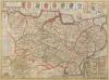
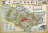
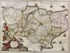
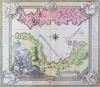
John Speed (1552-1529) - Coloured engraving - "Kent with her Cities and Earles Described and Observed" - Map of Kent showing plans of Canterbury and Rochester, with seven armorials and Royal Coat of Arms to top edge, 14.75ins x 19.75ins, published by Dicey & Co, 1770 (paper somewhat discoloured), in Hogarth frame and glazed £150-200
|
|
|
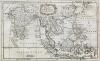
Thomas Bowen (fl. 1767-1790) - engraving - Map of East Indies, showing Borneo, Philippines, India, Sumatra and Taiwan, 7ins x 11ins, framed and glazed £100-150
|
|
|
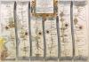
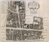
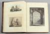
I. Hilton for Edward Jacob - Engraving - "An Accurate Plan of the Town of Faversham in the County of Kent - An Antient Member of the Cinque Ports" - Detailed plan of the town with vignette depicting a prospect of the remains of Faversham Abby, 21.5ins x 36.5ins (thought to date about 1770), in oak frame and glazed £200-300
|
|
  |
B. Cole - Engraving - "Breadstreet Ward & Cordwainers Ward....", 9ins x 14.25ins, and one other 18th Century engraving - Map of "Cheape Ward....", 12.5ins x 13.75ins, published 1754, both in modern moulded frames and glazed £120-160
|
|
|
Herman Moll (1654-1732) - Coloured engraving - Map of Kent, 7.5ins x 12.25ins, and John Cary (1754-1835) - Coloured map of Kent, 8ins x 10ins, both framed and glazed, and a folio of loose 18th and 19th Century engravings of mainly topographical and historical interest, various £100-120
|
|
|
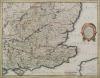
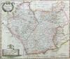
Henricus Hondius (1587-1638) - Coloured engraving - Map of South East England (for Mercator's Atlas), 14.5ins x 18.25ins, probably published 1633-1641 in conjunction with Jan Jansson (unframed) £150-200
|
|
  |
Jan Jansson (1596-1664) - Coloured engraving - "Cantium Vernacule Kent", 15ins x 19.5ins, the double page engraved with cartouche, armorials and ships and Latin text to verso, in Hogarth frame and glazed to both sides, and Robert Morden (17th/18th Century) - Coloured engraving - Map of 'Leicestershire', 14ins x 16.5ins, in modern Hogarth style frame and glazed £120-160
Note: Jansson map originally published for his "Atlas Novus", Amsterdam 1646-1666
|
|
|
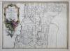
Joseph Nicholas de L'Isle (1688-1768) - Coloured engraving - "Terrae Sanctae Tabula" - Map of the Holy Land, 13.5ins x 19ins, and two other maps, all framed and glazed £150-200
|
|
|
17th Century Dutch School - Engraving - "Abbildung der Statt und Revier Von Rochefter, Chetham, etc...." - Dutch Naval attack in the Medway 1667, in modern gilt frame and glazed £100-150
|
|
|
Johann Baptist Homaan (1663-1724) - Coloured engraving - "Plan of the Siege of Corfu by land and by sea", 19ins x 21.75ins, framed and glazed £200-300
Note: The map shows the West coast of Corfu including the town of Kerkira and its siege on July 5th 1716
|
|
|
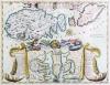
After Giovanni Giacomo de Rossi - Coloured reprint - "Isola de Malta Gozzo Comino et Cominotto" - Inset with plan of fortifications with corresponding key, 15.75ins x 21ins, and after Giovanni Maria Cassini - Coloured reprint - "Mappmondo O Descrizione Generale del Globo Terraqueo...", 15.5ins x 21ins, both in modern gilt frames and glazed £200-300
|
|
|
A collection of over four hundred and sixty Sotheby's, Christies and other auction catalogues of Pictures, Watercolours, and Drawings interest and other interest, dating from 1987 to 2007 various (the majority of catalogues retaining sale results lists), and a small selection of dealer's and exhibition catalogues, various £600-800
|
|
|
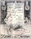
Attributed to Alfred Palmer (1877-1951 ) - Charcoal - Poster worded 'East Kent Art Society - St George's Hall, Canterbury' and drawn with figure of painting mannequin, 46ins x 36ins, unsigned, in later frame and glazed £200-300
|
|
|
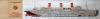
Two coloured posters giving longitudinal coloured sectional views of French liners, 12ins x 62.5ins and 12.5ins x 67ins, both framed and glazed £80-120
|
|
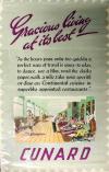 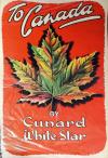 |
A 1950's Cunard travel poster - "Gracious living at its best" (No. B.410), 40ins x 25ins, and one other Cunard White Star Line travel poster depicting a maple leaf and worded "To Canada" (No. B100), 35ins x 22.5ins £100-150
|
|

|
A 1950's Cunard Line travel poster - "Europe to all America - Fastest Ocean Service in the World", depicting R.M.S. Queen Mary arriving at New York and R.M.S. Queen Elizabeth leaving the ocean terminal, Southampton, 40ins x 25ins (No. B442) £300-400
|
|
|
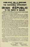
A rare Irish poster - "The Declaration of Irish Independence 1916" - Broadside poster 15ins x 10.25ins, bearing the wording of the Declaration as issued during the Easter Rising in Dublin in 1916, printed in black with various numerous typographical mistakes and bearing the names of Thomas J. Clarke, Sean MacDiarmada, Thomas MacDonagh, P.H. Pearse, Eamonn Ceannt, James Connolly and Joseph Plunkett, bearing a watermark for Swift Brook Paper Mill of Saggart, South Dublin County, and the reverse bearing hand stamped printer's mark "Fitzpatrick, 12 Dublin St., Dublin" £4000-6000
Provenance: This example was brought back to England by a British soldier serving in Dublin during the Rebellion and Civil War and has recently been discovered amongst his effects. The poster has marks for drawing pins to each corner and has been folded four times. There is a short split along the centre fold and a couple of small edge tears
Note: This is believed to be the only other intact copy of this version of the printing of the Proclamation in existence. It conforms in every respect to the other known copy of this version which is kept in the O'Hegarty Collection at the Spencer Research Library in the University of Kansas, U.S.A. The original Proclamation was printed in Liberty Hall, Dublin, on Sunday, 23rd April for distribution the following day, Easter Monday, set for the Easter Rising of the Rebels
|
|
|
|
|
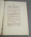
William Lambarde - "A Perambulation of Kent conteining the description, hystorie and customes of that Shyre" imprinted at London by Edm. Bollifant, 1596 (one volume with replacement card of the Beacons and with leather binding) £120-160
|
|
|
William Lambarde - "A Perambulation of Kent conteining the description, hystorie and customes of that Shire", third edition, corrected and enlarged, printed by R. Hodgkinson for D. Parker living at The Rainbow in Fleetstreet, neer the Inner Temple Gate, 1638 (one volume containing a card of the Beacons and with later leather binding), and Richard Kilburne - "A Topographie or Survey of the County of Kent" printed by Thomas Mabb for Henry Atkinson and sold at his shop in Staple-Inn Gate in Holborne, London 1659 (one volume with replaced leather spine) and Thomas Philpott - "Villare Cantianum or Kent Surveyed and Illustrated" printed by William Godbid and sold at his house over against the Anchor Inne in Little Brittain, London 1659 (one volume with later leather spine and marbled boards) £200-300
|
|
|
William Somner - "The Antiquities of Canterbury in Two Parts" printed for I. Knaplock at The Angel & Crown in St. Paul's Church-yard, London 1703 (one volume with later binding with wine leather spine) £120-160
|
|
|
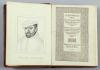
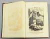
John Harris - "The History of Kent in Five Parts" printed and sold by D. Midwinter at The Rose & Crown in St. Paul's Church-yard, London 1719, containing folding map of Kent engraved by Samuel Parker 1719 and numerous birdseye views of important houses and properties in Kent (one volume in replaced leather spine and original boards) £1500-2000
|
|
|
Reverend J. Dart - "The History and Antiquities of the Cathedral Church of Canterbury", printed and sold by J. Cole, London 1726 (one gilt tooled brown leather bound volume - slight wear and damage to binding) £200-300
|
|
|
William Gostling - Two copies of "A Walk in and about the City of Canterbury", printed by Simmons & Kirkby and William Blackley, Canterbury 1779 and 1825 respectively (third and new editions - one volume in three quarters brown leather binding, the other in black three quarters leather binding) £120-160
|
|
|
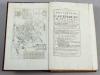
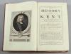
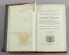
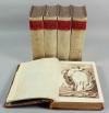
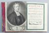
Edward Hasted - "The History and Topographical Survey of the County of Kent" printed for the author by Simmons & Kirkby, Canterbury 1778-1799 (four volumes containing - Map of Kent, Maps of the Hundreds and other engravings in four tooled leather folio sized bindings) £1800-2500
|
|
|
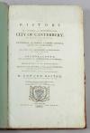
Edward Hasted - "The History of the Antient and Metropolitical City of Canterbury" printed by Simmons & Kirkby, Canterbury 1799, containing Plan of the City and numerous additional engravings (one volume with leather spine and marbled boards), and one other single bound volume of engravings from "Hasted's History of Kent" (first edition - in full leather binding) £300-500
|
|
|
W. Woolnoth - "A Graphic Illustration of the Metropolitan Cathedral Church of Canterbury", containing twenty plates engraved by himself, and a selection of other prints and engravings of Canterbury interest, published by T. Cadell & W. Davies, Strand, and J. Murray, Albemarle Street, London 1816 (one volume with tooled leather spine) £100-150
|
|
|
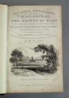
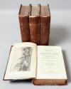
W.H. Ireland - "England's Topographer or a New and Complete History of the County of Kent" illustrated with a series of views from original drawings by George Shepherd, H. Gastineau, etc, published by George Virtue, Ivy Lane, Paternoster Row, London, July 1828 (four volumes with later vellum bindings), and Samuel Ireland - "Picturesque views of the River Medway from the Nore to the vicinity of its source in Sussex" printed by T. & J. Egerton, Whitehall, London 1793 (one volume containing numerous aquatint views, in leather binding) £250-400
|
|
|
W. H. Ireland - "England's Topographer or a New and Complete History of the County of Kent", published by George Virtue, London 1828 (four three quarters maroon leather bound volumes) £175-250
|
|
|
W.H. Ireland - "A New and Complete History of the County of Kent", volumes 1 to 4, published by George Virtue, London 1828-1840 (four three quarters red cloth bound volumes - bindings in poor condition) £100-150
|
|
|
J.P. Malcolm - "Excursions in the Counties of Kent, Gloucester, Hereford, Monmouth and Somerset in the Years 1802, 1803 and 1805", second edition, published by and for Nichols, Son, and Bentley, Red Lion Passage, Fleet Street, London 1814 (one volume illustrated with various engravings, with leather spine), and "The Picturesque Beauties of Great Britain - Kent" published by George Virtue, 26 Ivy Lane, Paternoster Row, London (one volume illustrated with numerous engravings and with modern leather spine and marbled boards) £120-160
|
|
|
Phillip Parsons - "The Monuments and Painted Glass of Upwards of One Hundred Churches chiefly in the Eastern Part of Kent", printed and sold by Simmons, Kirkby & Jones, Canterbury 1794 (one volume with tooled leather spine and marbled boards) and Samuel Jeake - "Charters of the Cinque Ports, Two Ancient Towns and their Members" printed for Bernard Lintot at The Cross-Keys, between Temple-Gates in Fleet Street, London 1728 (one volume with wine leather spine and marbled boards) £100-150
|
|
|
The Reverend John Lewis - "The History and Antiquities of the Abbey and Church of Faversham in Kent" printed 1727 (one volume with numerous addendum and handwritten notes - tooled leather spine and plain leather boards) £150-250
|
|
|
The Reverend John Lewis - "The History and Antiquities as well as Ecclesiastical as Civil of the Isle of Thenet in Kent" printed for the author and for Joseph Ames and Peter Thompson, London 1736 (one volume with tooled leather spine and calf boards) £120-160
|
|
|
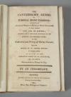
Edward Jacob - "The History of the Town and Port of Faversham in the County of Kent" printed for the author by J. March and sold by B. White in Fleet Street, London 1774 (one volume with green tooled leather spine and patterned boards), a bound Catalogue of the collection of curious subjects of natural history of Edward Jacob, Esq, of Faversham, sold at auction by Mr. Gerard at his house in Litchfield-Street in St. Anne's, Soho, Monday June 8th 1789 and three days following, and "The Lamentable and Truve Tragidie of M. Arden of Feversham in Kent" reprinted by J. & J. March for Stephen Doorne, Bookseller in Feversham 1770 (one volume with full leather binding £150-250
|
|
|
Edward Jacob - "The History of the Town and Port of Faversham in the County of Kent", printed for the author by J. March and sold by B. White in Fleet-Street, London 1774 (one volume with replaced spine and marbled board) a bound copy of "Faversham Borough Custumal Circa 1400-1740" (one volume with red cloth binding) and "The Common Place Book of Faversham" illustrating various charters and documents, photographed and reproduced by C.F. Boyle Ltd, Western Works, Faversham 1948 (one volume with full leather binding) £100-150
|
|
|
Sir George Sondes - "His Plaine Narrative to the World of all Passages upon the death of his Two Sonnes printed in the Yare 1655 London" (one volume in replaced binding), three other smaller books of the Sondes Family interest £100-150
|
|
|
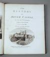
Reverend W. Darell - "The History of Dover Castle", printed for Hooper & Wigstead, London 1797 bound with Francis Grose - "A Provincial Glossary", printed for Edward Jeffery, London 1811 (one black cloth bound volume) £100-150
|
|
|
Reverend John Lyon - "The History of the Town and Port of Dover", volumes 1 and 2, printed for the author by Ledger & Shaw, Dover 1814 (two black cloth bound volumes) £120-160
|
|
|
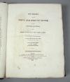
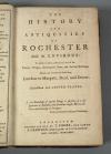
"The History and Antiquities of Rochester and its Environs", printed and sold by T. Fisher, Rochester 1772 (one volume with original brown leather binding - slight damage to binding - folding map to front) £50-70
|
|
|
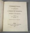
Paul Amsinck - "Tunbridge Wells and its Neighbourhood", with etchings executed by Letitia Byrne, published by William Miller & Edmund Lloyd, London 1810 (one volume with three quarters brown leather binding - binding possibly later) £150-200
|
|